LiDARスキャンシステム
(20)
Geosun gAirHawk シリーズ GS-100C+ LiDAR スキャニング システム エントリーレベルの 3D データ収集 Livox Avia センサー サポート UAV ドローン
価格: Negotiation
MOQ: 1
納期: 7-10 works days
ブランド: Geosun
ハイライト:GS 100C Livox Avia LiDAR、gAirHawk Livox Avia LiDAR、200HZドローン搭載ライダー
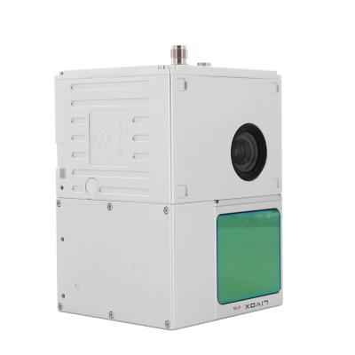
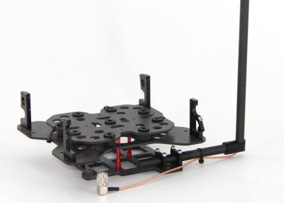
GS-100C+ LIDARスキャンシステムエントリレベルの3Dデータ収集リボックスアビアセンサー
Geosun Gairhawk Sesries GS-100C+ LIDARスキャンシステムGairhawk GS-100C+は、一種の軽いコンパクトなライダーポイントクラウドデータ収集システム、統合されたLivox New Generation Laser Scanner、GNSSおよびIMUの位置決めおよび態度決定システム、およびストレージコントロールユニットは、高予測点クラウドデータとリッチな画像情報をリアルタイム、ダイナミックに、大規模に収集することができま... もっと見る
➤ 訪問 Webサイト
UAVLiDARシステム
(67)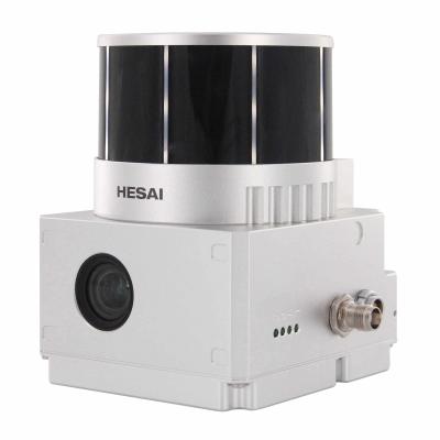
ドローンライダースキャナーGeosunGS-130X3Dスキャン内蔵RGBカメラトータルエアリアルソリューションDJIM300費用対効果
価格: Negotiation
MOQ: 1
納期: 10-15 works days
ブランド: Geosun
ハイライト:1.6平方キロメートルUAV Lidarシステム, HESAI XT UAV Lidarシステム, HESAI XT uav lidarセンサー
ドローン ライダー スキャナー Geosun GS-130X 3D スキャニング 内蔵 RGB カメラ 総合空撮ソリューション DJI M300 費用対効果
UAV LiDAR スキャニング システムの応用
LiDAR 搭載ドローン (DJI M300 および GS-130X)
の無料試用ソフトウェアuav LiDAR スキャニング ... もっと見る
➤ 訪問 Webサイト
gCollector-M302 都市 3D アプリケーションにおける道路情報収集 LiDAR システム
価格: USD 70,000.00/Unit
MOQ: 1
納期: 10-15 works days
ブランド: Geosun
ハイライト:道路情報収集LiDARシステム、3D道路情報収集LiDARシステム、
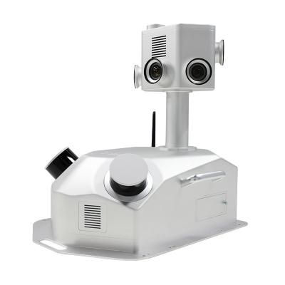
GCOLLECTOR-M302 ROAD情報コレクションLIDARスキャンシステム
GCOLLECTOR-M302 ROAD情報収集システムは次のとおりですLidar、Panoramic Cameras、GNSS、IMU、WS、PCを一緒に統合するモバイルリアルスケンス収集システム。センチメートルレベルの高精度ポイントクラウドとパノラマビューデータを収集するために、車、列車、または船にマウントでき、インテリジェントソフトウェアはルート最適化、キャリブレーション、データ処理、結果抽出などの機能を独立して実装できます。 Gcollector Road Information Collectio... もっと見る
➤ 訪問 Webサイト
変形監視システム
(1)
1mm精度のGNSS変形監視システム
MOQ: 2
納期: 10-15 works days
ブランド: Geosun
ハイライト:Geosun 1mm GNSS監視システム、1mm GNSS変形監視システム、3Dグラフィックス変形監視システム
高性能調査GNSS受信機、CORSリファレンスステーション、変形監視システム
Geosun gMOSは、従来の静的監視方法とは異なり、グローバルで高度なリアルタイム高精度GNSS動的測位技術を採用したGNSSリアルタイム高精度変形監視システムです。システムは、ターゲットの1日24時間のリアルタイム監視を提供し、出力周波数は1Hzです。動的3D監視精度は3mmに達します。日次、週次、年次の統計レポートは、gMOSによって簡単に作成できます。GPRSと有線ネットワークの両方をサポートしているため、データをシームレスに送信できます。
gMOSは、ダム、橋、歴史的建造物、海上プラットフォー... もっと見る
➤ 訪問 Webサイト
GNSSINSシステム
(2)
GPS BDS GLONASS GNSSINSシステムによる測位と高度
価格: Negotiation
MOQ: 1
納期: 5-10 Working Days Since Payment
ブランド: Geosun
ハイライト:GLONASS GNSS INSシステム、BDS GNSS INSシステム、GPS GNSSINSシステム
GPS BDS GLONASS GNSSINSシステムによる測位と高度
AGS 300GNSSINSシステム 高精度の慣性航法(IMU)モジュールを追加し、航空飛行中に胴体がどのように傾いても、位置、速度、および3D姿勢情報を正確に提供できます。
プロのソフトウェアのデータ処理後、 AGS 3000.05 mの3次元位置精度、0.02 m / sの速度、0.080度の方位、0.030度のピッチ/ロール、最大200Hzのデータサンプリングレートを提供します。とAGS 300、UAV空中リモートセンシングは、地上制御点から完全に解放することができます。これは、特に、ストリップ領域、不規則... もっと見る
➤ 訪問 Webサイト
軌道処理ソフトウェア
(4)
Geosun GNSSINSシャトル軌道処理ソフトウェア
価格: Free
MOQ: 1
納期: 1-3 Working Days Since Payment
ブランド: Geosun
ハイライト:GNSS INS軌道処理ソフトウェア、Geosunシャトルソフトウェア、Geosun軌道処理ソフトウェア
独立した所有権を持つ Shuttle ソフトウェア
軌道処理機能付きシャトルソフトウェア、GNSS/INSソフトウェア
Shuttle は、Wuhan Geosun Navigation Technology Co., Ltd. が独自に開発した高精度 GNSS/INS 測位および姿勢決定後処理ソフトウェアで、高精度 GPS/GLONASS/Beidou II/Galileo 測位速度測定プロセッサ (GGPoS) を内蔵しています。 )。このシステムは、マルチモード GNSS 測位速度測定、GNSS/INS 複合測位姿勢測定を処理でき、動作点 (またはキャリア) のセンチメートルレベルの... もっと見る
➤ 訪問 Webサイト
カラーPTファイル出力を備えた3DLiDARデータ処理ソフトウェア
価格: Free
MOQ: 1
納期: 1-3 Working Days Since Payment
ブランド: Geosun
ハイライト:gAirhawk LiDARデータ処理ソフトウェア、LASファイル出力LiDAR処理ソフトウェア、リアルタイムデータ処理ソフトウェア
gAirHawkの紹介
カラー PT ファイル出力を備えた 3D LiDAR データ処理ソフトウェアgAirHawk は、Geosun Navigation が自社開発した LIDAR スキャン システム取得監視および点群コンピューティング ソフトウェアです。フィールド データ収集システムのリアルタイム設定と監視、リアルタイムおよび後処理レーザー スキャン データのデコード、点群データの計算と表示、Geosun LIDAR スキャン シ... もっと見る
➤ 訪問 Webサイト
PPKソリューション
(1)
写真測量キネマティックディファレンシャルポジショニングPPKソリューション
価格: Negotiation
MOQ: 1
納期: 5-10 Working Days Since Payment
ブランド: Geosun
ハイライト:写真測量PPKソリューション、キネマティックディファレンシャルポジショニングPPKソリューション、AG213PPK機器
AGS213レシーバー
写真の測量とマッピングのためのPPK機器アプリケーション
高性能空中GNSS受信機
AG213シリーズはGeosunSpatialによって製造されており、低消費電力で高性能のGNSS受信機、精巧な設計、持ち運びが簡単で高精度のGNSS OEMマザーボード、最高レベルの測量データを備えた空中散布に特化しています。
品質保証は、GPS、IMU、光電気エンコーダーの3つの異なる形式の同時入力をサポートし、GPSがロックを失っている間も継続的かつ効果的に機能します。
安定性と信頼性に基づいたAG213。
安定した信頼性の高いLinuxシステムに基づくAG213、組み込みの... もっと見る
➤ 訪問 Webサイト
LiDARアクセサリ
(3)
Geosun DJIM600ドローン取り付けキットLiDARアクセサリ
価格: USD 500/SET
MOQ: 1
納期: 1-3 Working Days Since Payment
ブランド: Geosun
ハイライト:DJI M600ドローン取り付けキット、Geosun LiDARアクセサリー、DJI M600LiDARアクセサリー
DJI M210、M300、M600Proおよびその他のブランドの取り付けキット。
DJIドローンは、特にDJI M210、M300、M600Proの測量とマッピングに適したアプリケーションです。それは人気があり、世界中の税関で広く使用されています。
Geosunは、DJIドローンに合わせるために、DJI M210、M300、およびM600Proの取り付けキットを設計しました。
そして、ペイロードを考慮して、素材はカーボンファーバーで強くて軽いものが選ばれています。
DJIM600ドローン用の取り付けキット
もっと見る
➤ 訪問 Webサイト
RTKソリューション
(2)
ベース/ローバーステーション
価格: Negotiation
MOQ: 1
納期: 5-10 Working Days Since Payment
ブランド: Geosun
ハイライト:GPS受信機RTKソリューション、2GバイトRTK機器、2GバイトRTKソリューション
RTK 機器 測量および地図作成機器 GPS 受信機
Easynavtech R7GNSS レシーバーで競争力を高めましょう。R7 には、現場での生産性を最大限に高めるための高度なテクノロジーが装備されています。IP67の耐久性を備えた設計により、過酷な環境での作業が可能です。4G GSM モデム、内蔵無線 (Rx のみ)、RTK Aid 機能、60°傾斜 IMU 機能を組み合わせた R7 は、移動局の受信機として最適です。
軽量 デザイン:
簡単 に 運ぶ
軽量でコンパクトな設計の利点を生かし、さまざまな複雑な環境に簡単に持ち運べ、あらゆる移動局のシナリオで使用できます。
ウェブ... もっと見る
➤ 訪問 Webサイト
LiDARドローン
(2)
マッピング 測量 3400mm ホイールベース VTOL 固定翼 LiDAR ドローン
価格: Negotiation
MOQ: 1
納期: 15-20
ブランド: Geosun
ハイライト:Geosun VTOL固定翼ドローン、2000mm翼幅VTOL LiDARドローン、2000mm翼幅LiDARドローン
マッピングと測量のための VTOL 固定翼ドローン アプリケーション
GS-S300 は、シンプルで滑らかな外観デザインを備えた純電動 VTOL 固定翼ドローンで、時速 90km での巡航が可能で、有効バッテリー寿命は 2.5 時間です。LiDAR、プロ仕様の航空測量カメラ、高照度センサーを簡単に装備でき、効率的な運用を実現します。
革新的な製品設計の GS-S300 は、信頼性の高い冗長安全制御システムを備えています。親密なユーザーエクスペリエンス、センチメートルレベルの測位精度、ワンボタン離陸と着陸、ユーザーフレンドリーな操作プロセス。最先端の積載設計、豊富な積載オプション、ミッ... もっと見る
➤ 訪問 Webサイト

SLAM LiDAR スキャニング システム スラム バックパック 3D スキャン 地下 屋内
価格: Negotiation
MOQ: 1
納期: 5-7 works days
ブランド: Geosun
ハイライト:ハンドヘルドUAVLiDARスキャンシステム、スラムバックパックUAV LiDARスキャンシステム、3DUAVLiDARスキャンシステム
Geosun GfireeyeシリーズGS-100G LIDARスキャンシステムHESAI XT16グラウンドマッピング3Dデータ収集の下でのスラムアルゴリズム Geosun GfireeyeシリーズGS-100G LIDARスキャンシステムGS-100Gは、Geosun Companyによって独立して開発されたハンドヘルドLIDARスキャンシステムの一種です。小さなボディを持つシンプルなデザインを採用して、携帯しやすく、操作しやすく、さまざまなセンサーを使用して柔軟になります。屋内と屋外のシーンの。SLAM Serial Solution.pdf SLAM LIDARスキャンシステム... もっと見る
➤ 訪問 Webサイト